PHOBOS-GRUNT BEFORE REENTRY
Any use of one of these images other than strictly private must be subject to prior authorization from legault@astrophoto.fr
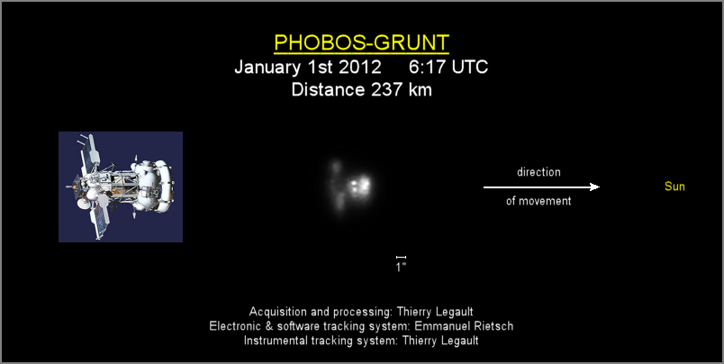
This
video of Phobos-Grunt
was taken from the Calern plateau Observatory (above Nice, French Riviera) on
January 1st 2012, during a zenithal passage (culmination at 88.5° of
altitude at 6:17:24 UTC, direction NNE). Distance to observer: 237 km. Speed:
7.75 km/s. Angular speed at culmination: 1.85°/s (without tracking system, at
the scale of the video the satellite would cross your screen in about 1/30s).
Phobos-Grunt is out of control and its atmospheric reentry is currently
scheduled for mid-January.
On the image and video below, thanks to the specific orientation of the telescope mount (calculated with www.calsky.com), the movement of the satellite during the whole passage remains strictly horizontal, from left to right. Around culmination of the satellite, the Sun is on the right side and the trajectory of Phobos-Grunt is directed toward the Sun (azimuth of the apparent orbit plane: 122° ESE; azimuth of the Sun: 114° ESE). The images show that Phobos-Grunt is moving backwards, with the solar panels deployed but not lightened by the Sun. There is no sign of tumbling, and a video taken 24 hours before (Dec 31st) shows the satellite in a similar orientation. According to experts, that corresponds to an orientation driven by aerodymanic forces: the heaviest parts (tanks) ahead and the parts subject to the highest atmospheric friction (the solar panels) backward. The image below is a stack of 30 raw frames, with 50% enlargement.
Instrument: Celestron
EdgeHD 14” Schmidt-Cassegrain telescope (focal length of 7000mm) on automatic
tracking system, as described on this
page. Camera:
Lumenera Skynyx L2-2 (12-bit files in fits format). Raw files are available on
request.
This video
sequence shows Phobos-Grunt in the original acquisition size, it begins at 6:16:41 and ends at 6:18:01 UTC, for 963 images (acquisition
rate: 12 fps, processed video rate: 25 fps). A the beginning of the video
Phobos-Grunt comes from West-North-West (direction opposite to the Sun), it is well
illuminated and we mainly see the bottom of the main tank and the backside of
the solar panels. At the end of the video it's going East-South-East, it's dimmer
because backlit and we see the edge of the main tank and just the edge of the
solar panels (the panels themselves are not lightened).
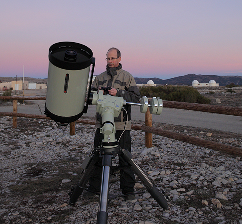
The
observation site (43°45'05"N, 6°55'26"E),
with the twin Soirdete interferometer domes in the background and, on their
left, the Moon-laser
telescope destined to measure the distance of the Moon thanks to reflectors left by Apollo
missions. This observatory is 850 km from my home.
Notes about the reliability of small satellite images at the limits of telescopic resolution
At zenith, the maximum
angular size of Phobos-Grunt, which is 5 times smaller than the Space Shuttle,
is only about 6 arcseconds. This size is to be compared with the diameter of the
Airy disc for a 14” telescope: 0.78 arcsec (1.1 arcsec for a 10” telescope).
This implies that, on the raw images, the satellite covers a very small amount
of pixels and that artifacts from many origins can appear and can even outclass
any real detail that would be recorded: atmospheric (turbulence, dispersion….),
instrumental (diffraction, various optical aberrations such as chromatism, coma,
astigmatism, shaking due to manual tracking…), electronic (noise, image
compression…).
To avoid to the maximum
these risks and guarantee that all details are true, in addition with the
automatic tracking system, the following solutions were chosen:
- a large aperture telescope (14” Schmidt-Cassegrain) with very good optics and a simple Barlow lens in front of the sensor.
- a
12-bit monochrome camera
(uncompressed images in astronomical “fits” format) with a green filter: in
addition with the turbulence that is able to create any arbitrary pattern on
each raw image (as illustrated on
this page), the atmosphere also acts like a prism, spreading colors
along the vertical axis (blue towards zenith and red towards horizon). At 45°
above the horizon, this dispersion of colors exceeds 1.5 arcsecond, to be
compared with the angular size of Phobos-Grunt (less that 4 arcseconds at 45°
above the horizon). This means that a color camera is useless for a so small
object since real color variations will be hidden by the atmospheric dispersion.
Moreover, the Bayer matrix of the color sensor introduces, on an object covering
a few pixels, artifacts that may subsist even if the image is converted to
black&white.
- application of a processing destined to improve the reliability of the images: all planetary imagers use images stacking since they know that one single raw image inevitably contains noise and that no, or very little processing, can be applied. Each image of the video above is a stack of 10 consecutive raw images, in order to improve the signal-to-noise ratio and to smooth the effects of turbulence (processing is performed with scripts under Prism astronomical software). On a single image, turbulence creates speckles which are groups of bright spots duplicated from the Airy disk, as described here: http://en.wikipedia.org/wiki/Speckle_imaging.
-
the whole video sequence
is presented, and not only one (or a few) arbitrarily selected image, in order
to show the consistency of the details recorded.
On the contrary, Ralf
Vandebergh’s images of Phobos-Grunt taken on Nov 29th 2011
accumulate all handicaps. A standard JVC camcorder is used, delivering
8-bit compressed video files. The lens of the camcorder is placed behind an
eyepiece (on a 10” Newtonian), this represents a lot of glass and off-axis
aberrations and contributes to color artifacts due to the optics and the sensor,
as demonstrated on this
analysis of Nanosail images taken by the same author (this analysis
shows that the colors, as well as the shape visible on the image, do not
correspond to any real detail). Although manual tracking of the telescope on an
object moving at almost 2°/s and atmospheric turbulence (strong pressure
gradient and 50 km/h winds gusts over Netherlands at that moment, conditions
associated with significant turbulence) are able to create any distorted shape,
only one raw image is arbitrarily chosen and processed by heavy enlargement
(between 5 and 10 times) and by other processing able to make artifacts (such as
noise and compression effects) look like true details. Manual tracking implies
that the object wanders in the field of view of the camera and even goes in and
out of this field, the problem being that the off-axis images given by an
eyepiece and a camcorder lens suffer from off-axis aberrations, especially
astigmatism that may lead to extended and complex patterns. The details that are
supposed to be visible on these images are questionable also for the following
reasons:
- considering the equipment
used, the size of Phobos-Grunt on the raw video is smaller than half the size of
the satellite on my own images and these “details” are smaller than the
smallest details ever recorded by the same author on the ISS,
- the correspondence of
these “details” with structures of Phobos-Grunt visible on reference
drawings and photos is vague: in the absence of any indication of scale and of
orientation of the satellite with regards to its trajectory and to the Sun (and
thanks to the ability of the human brain to find imaginary correlations between
groups of bright patches), many arbitrary and unverifiable interpretations are
possible. Picking up an image that "looks nice" and trying all the
possibilites of orientation of the satellite until a vague correspondance is
found, and then deducing that the image contains real details, is a vicious
circle reasoning.
The strong enlargement is performed at least in two steps, one with pixel resampling and one with pixel duplication. As a result, the processed image gives the illusion that the satellite covers much more pixels on the raw image that it actually does.
Unfortunately, the author
does not accept to provide his raw video sequences of this satellite or any
other one, prohibiting any possibility of reliability and consistency analysis
of the raw data by peers.